
CE Stitch-up for Regional Transport Committee
So, this report from the Wellington Region Chief Executives probably shouldn’t come as a surprise. After all, despite promising an open working group to discuss roading requirements in the region, NZTA proved false (quelle surprise) and instead opted for secret closed-door meetings where they could spoon-feed the CEs their preferred option without having to worry about anyone calling them on their BS.
And BS it most certainly is. If it weren’t, they wouldn’t need to work so hard to prevent alternate voices being heard, would they? Here’s just one example: back in December, we OIA’d the information NZTA gave to the CEs — the information that the CEs have had long enough to produce the report being tabled Monday — and have been told they still won’t be able to get it to US for weeks yet, 10 weeks after we submitted the question. Yeah.
So what might NZTA not have told the CEs in their closed-door meetings?
That the resilience argument they’re leaning on to force through the Takapu Road option is pure fantasy. The geotechnical report they’re basing all this on STOPS AT GRENADA VILLAGE. That’s right. Their analysis of the Takapu Valley route is based on, I kid you not, Google maps and a vague notion that most of the rock around Wellington is more or less the same. Tell that to the poor sods trying to get the footings sorted for the Transmission Gully bridge over Cannons Creek, at the top of the valley.
NZTA’s “resilience expert” didn’t know — and didn’t do enough homework to find out — that there’s an active fault right where they want to put the road. Anybody who’s claiming to be qualified to site a road in Wellington should know by now that tidy little valleys like Takapu are *created* by fault lines. So, do you think they’ve included paying GNS to study that fault line into their budget? Um, nope.
Did anyone point out to them that having two parallel highways could actually be a liability in a major event? That it could well just leave them with multiple routes to clear instead of one, dividing their resources? Ask Christchurch about triage. Do you think they showed the CEs the map showing the bit of SH1 that are listed as earthquake vulnerable? Including that controversial stretch above the school? And that NZTA has already said that if they get to build their shiny new Takapu highway, they’re not going to bother strengthening SH1? Because, you know, building a new greenfields road is ever so much more fun than maintaining an existing one. People complain about the road cones. Best to just let it fall down first, and then make people beg you to fix it — like they did with SH58.
How about consulting with Transpower and Wellington Energy, who are currently busy burying power lines right under where NZTA wants its interchange with TG to be? Also, nope. And that consultation isn’t free, either.
Did they show the CEs that there are already three different ways to get from the Tawa junction to Linden? Does adding a fourth through Takapu Valley really count as significant improvement to the network connectivity of theWellington Region? If they’re going to be ploughing more routes where there are already routes, aren’t there suburbs that might want to upgrade to TWO, before we gift Tawa with FOUR?
Did NZTA remind the CEs that the Parliamentary Commissioner for the Environment has already shot down a highway through Takapu Valley once already, when it was proposed as part of the Transmission Gully project? Evidently not, since the CEs are saying they think it’s a “logical” idea to extend TG down the valley. Oh wait, but according to NZTA, it’s not the same road the PCE rejected, because, hey, they’ve moved it 500 meters to the left, don’t you know? Totally different. Won’t wreck the community or the environment at all, now.
Were the CEs made aware that if the idea is to move heavy trucks from Petone to Transmission Gully — because they make a big noise about how they can make a nice even grade for heavy trucks — then SH58, being lower and shallower, is a much better choice…. oh wait! NZTA is planning to DOWNGRADE SH58, lowering the speed limit and slapping in some roundabouts. Making it safer by turning it into a slow, inconvenient road. See, that road’s no good anymore, so you’ll have to approve this new one. No, you don’t get a proper interchange on SH58, either. [UPDATE: Apparently, they found the money somewhere. Maybe because most of the submissions on P2G were asking why they heck they weren’t fixing SH58?] They’re too expensive if we build them on SH2. Fortunately, we can magically do them for half the cost on the other side of the ridge.
Yes, they’ve budgeted HALF the cost for the big interchanges they want to put in for P2G [$20M max] as they say SH58 would cost [$42M], or that Dowse actually did cost, despite the size and complexity being comparable, if not worse.
Speaking of budgeting, they’re also budgeting their earthworks — remember that 20-storey-deep canyon they want to blast through Korokoro? — at half what they were told was the likely cost back in 2011. And that’s assuming they only have to take the stuff 6km, which won’t get most of it out of the project area. Planning on using that dirt for a runway extension? Hope you have another hundred million lying around.
So if the biggest chunks of their budget are already off by a factor of two, what does that say about their Benefit-Cost calculations? Which, by the way, include some generous “future benefits”, but don’t have to include the future expense of maintaining the kilometers of highway they want to build parallel to the existing one, plus all the superfluous interchanges.
What else shall we look at? Time savings? They’ve said you can save 15 minutes on your drive between Tawa and Petone. Which is a good trick considering that drive usually only TAKES 15 minutes at peak hour. So NZTA’s roads are so good, they’ll send you back in time? And the time savings they want to bulldoze Takapu Valley for? Ooh. 10 seconds. As much as 30 seconds on a good day, southbound. Maybe a minute or two northbound. If you live in Kapiti, since that’s the only place that Takapu highway will take you, northbound (one-way ramps!). That’s if the multiple roundabouts and traffic lights they want to put at Tawa haven’t stuck you in a half-hour queue.
Here’s the kicker, though: NZTA is pushing the wrong road. Of the four options they analysed for the route north of the saddle, the one that was closest to the originally proposed route — what was “Option A” that came out at Grenada Village — was actually the best option, according to their own project goals AND their own internal experts. It had good natural resilience, did the least damage to the environment, didn’t have bizarre snarly interchanges that tried to mash together two motorways with eight local streets, a train station and a footpath, and most importantly, IT MADE THE TRAFFIC FLOW BEST. Seriously, they rejected the option that actually made the traffic flow best.
Five Roundabouts
…is how many roundabouts Takapu Valley and Grenada North residents will need to traverse to get into Tawa, according to the latest design from NZTA. It appears pedestrian and cycle commuters between the Takapu Road train station and Grenada North will be expected to navigate at least four of those. Because it’s all about reducing congestion and improving safety. (Yes, that was sarcasm.)
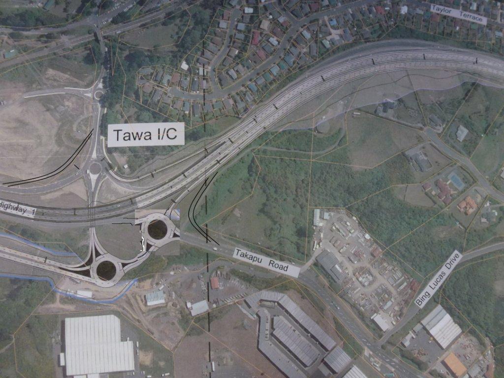
NZTA’s proposed Tawa interchange
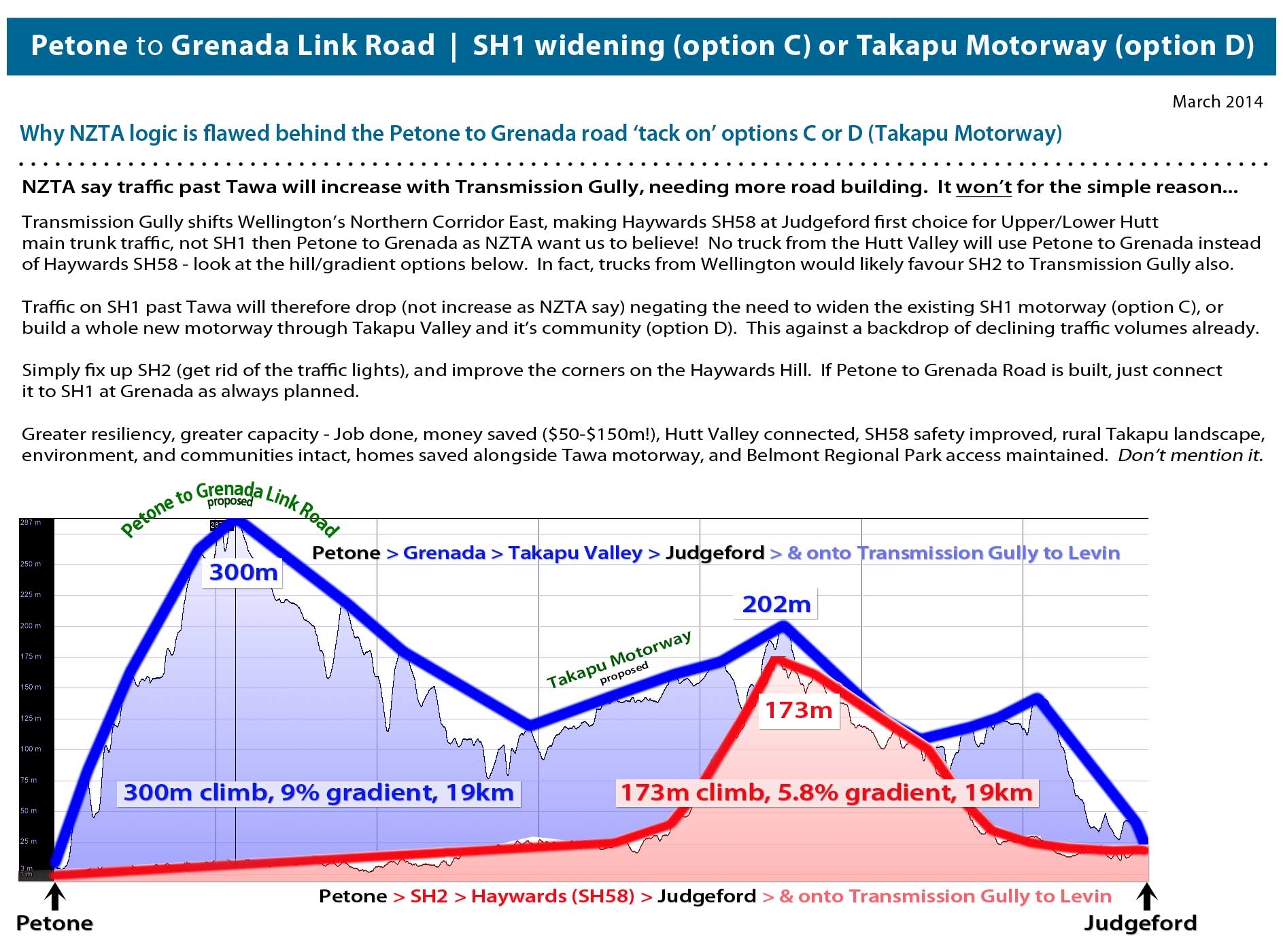
Transmission Gully Road changes traffic flows north from Wellington – SH1 vs SH2 (& SH58)
We were wondering what Transmission Gully Road would do to Wellington traffic flows once completed? Transmission Gully will shift the main Wellington northern corridor east, bissecting SH58 at Judgeford. What would this mean if you were a truck heading north from Wellington? Save for a few traffic lights on SH2, your route is clearly much better via SH2 and SH58 for fuel economy and wear and tear (see blue line below). So why are NZTA saying they need to invest $50-150m on extra capacity between Tawa and Porirua (SH1 widening or bulldozing rural Takapu Valley to make a ridiculous short parallel motorway), when for much less money they could remove traffic lights and fix a few bad corners on SH58?

Transmission Gully changes to traffic flows SH1 vs SH2 north from Wellington
These sudden proposals (options C and D) have arrived without Council knowledge and have totally circumvented the regional and district planning process. It’s clear to see that they’re being rushed through with haste by NZTA with no regard to wider regional needs. We say build Transmission Gully, and build Petone to Grenada Road if necessary, but wait to see what will happen before destroying communities and a whole rural valley.
NZTA tell us traffic volumes are going to miraculously skyrocket after Transmission Gully sending much more traffic past Tawa. We find this incredibly hard to imagine given traffic volumes have been dropping in Wellington, and when this elevation infographic diagram above suggests that Hutt Traffic (and possibly much Wellington Traffic) will prefer SH2/SH58 (over SH1 past Tawa) to Levin and beyond, further reducing flows.
Overall, this adhoc major infrastructure building by NZTA in road project silos is not serving the Wellington Region well. All these roads need to be put through a proper established strategic planning framework.
Intro to the Options
A quick rundown for viewers just joining us…
Okay, so what is the deal with this road?
Here’s the current road layout in Wellington. The “Project Area” we’re talking about here is the big wedge from basically where SH1 and SH2 split in the south, up to SH58 in the north.
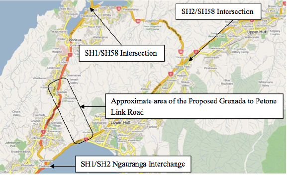
Figure 4.1 from the SKM Project Feasibility Report
NZTA and various local bodies have been talking about some version of this link road since at least 1991, and there are two primary problems they want the road to solve.
Problem 1: CONNECTIVITY
You’ve got SH1 in the west, and SH2 going up the Hutt, and there’re currently only two ways to get between one and the other:
- go down the Gorge at Ngauranga, and back up SH2 along the coast
- noodle around the Porirua inlets on SH58 and go down Haywards Hill
“Resilience” has become the buzzword du jour, and this is essentially an aspect of connectivity. If that bit of SH2 along the harbour gets eaten by the sea, or the hill falls on it, it’d be nice to not have to go all the way up to SH58 at Pauatahanui to get back to Petone.
Problem 2: CONGESTION
Ngauranga Gorge – it’s a big steep hill, with a couple of sharpish bends. In the AM peak, traffic backs up from here to Tawa. Out-of-peak, though, traffic flows are fine.
SH2 Aotea along the harbour to Petone – everything slows to a crawl at the PM peak, backing up all the way into town.
Really, this is just “connectivity” again – if we had another way to get from A to B, there’d theoretically be fewer cars using the congested routes.
So what’s the (current) plan?
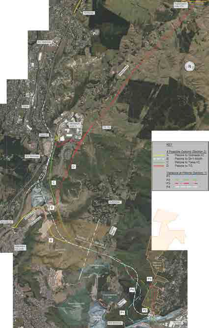
Figure 12.8: Options Selected for Development, from the Scoping Report
Clear as mud?
What the Petone to Grenada proposal does, basically, is builds a second gorge road, so in addition to SH1 coming up Ngauranga, there will be a new, slightly steeper gorge road coming up Korokoro from Petone and joining SH1 at… well there’s where it gets tricky.
They came up with four options for the Northern end.
Option A – Petone to Grenada
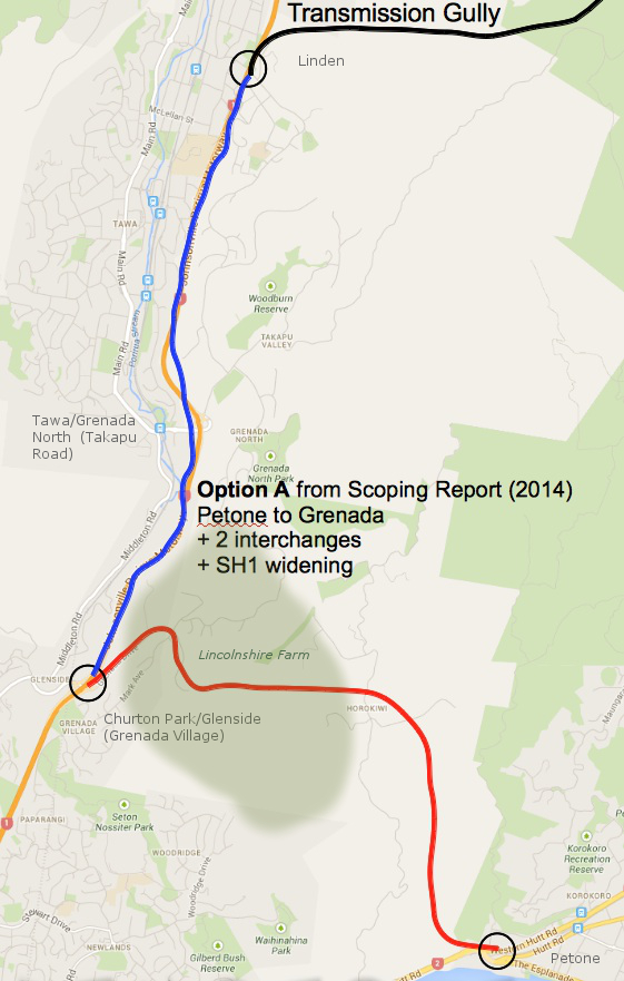
Option A: Petone to Grenada
Option A goes through Lincolnshire Farm to the Mark Avenue roundabout, and then runs along the existing Grenada Drive to the existing Grenada Interchange (Churton Park/Glenside) with SH1. Grenada Drive, the SH1 interchange, and the Mark Avenue roundabout would all be upgraded. This is basically the way that everyone has been expecting the link road to connect since the first detailed study in 1991. It’s written into the Lincolnshire Farm Structure Plan, and the local property lines have been drawn to keep out of the way.
Option A has the fewest number of interchanges, and according to the Scoping Report, does the best job of making traffic flow smoother and faster. It also has the least number of slip-vulnerable road cuts, and does the least amount of damage to the landscape.
This is one of the two “rejected” options.
NZTA says that if they go with this option, they would also need to widen SH1 from the Grenada interchange north to Transmission Gully. More on that later.
Option B – Petone to Not-Quite-Tawa
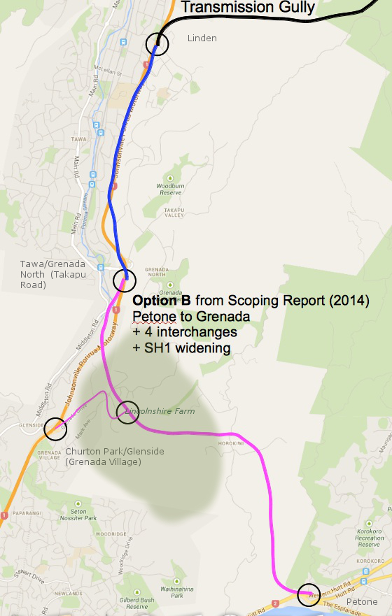
Option B: Petone to Not-Quite-Tawa
Option B connects to SH1 at a new interchange between the existing Tawa and Churton Park interchanges. The bit from the Mark Ave roundabout down Grenada drive is used as a link road (as-is, where-is apparently). The new interchange with SH1 south of Tawa is one-way pointing north. Meaning,
- If you’re coming from south of Churton Park, you get onto the P2G from Churton Park via the Mark Avenue link road.
- If you’re coming from north of Tawa, you get on at the new south-of-Tawa interchange.
- If you’re coming from Tawa, Grenada North, or Takapu Valley, you’re stuffed, because they’ve also taken the southbound ramps off the existing Tawa interchange. To get to Wellington or Petone, you’ll need to take Middleton Road to Churton Park and best of luck from there.
Not surprisingly, this one has the worst traffic flows. Also, it’s more expensive, because they routed it through the old Northern Landfill.
This is one of the two rejected options.
NZTA says that they would also need to widen SH1 from the Tawa interchange north to Transmission Gully. More on that later.
Option C – Petone to Tawa
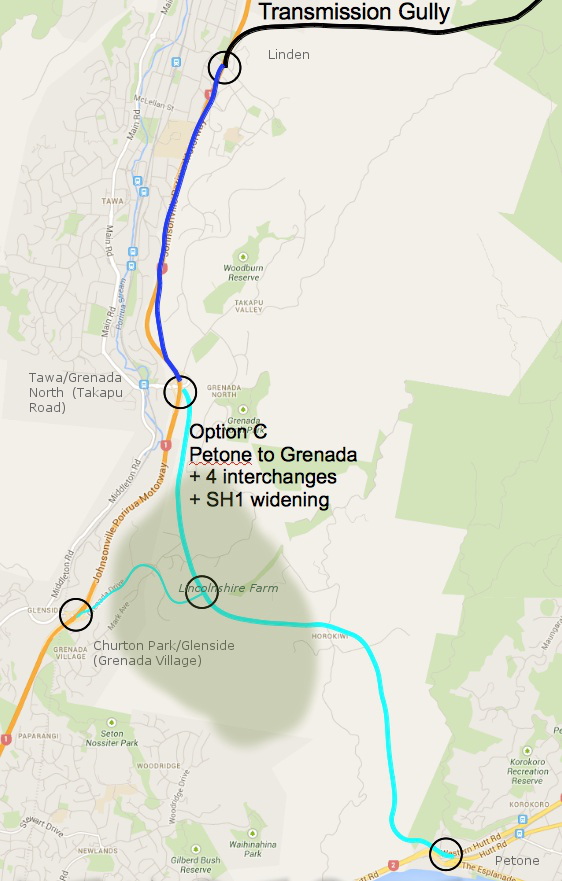
Option C: Petone to Tawa
Option C is much like Option B, except that they manage to miss the Northern Landfill, and instead they go through a bunch of homes that have just started construction in Grenada North. They then swoop up to connect to SH1 at the existing Tawa/Grenada North interchange. There’s about 2km where the two motorways run parallel to each other, something like 50 meters apart.
Tawa gets this:
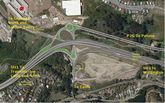
Figure 16-4: Modified Interchange at Tawa
You’ve got traffic from two high-speed motorways joining each other through a series of roundabouts, and if you’re coming from Tawa, Grenada North, or Takapu Valley, you get to try and leap into the middle of that. Be sure to have your life insurance up to date. And if you’re one of those that currently walks or cycles between the train station and points east… well, don’t.
From a resilience perspective, this option has some moderate road cuts that could be vulnerable to slips. For more day-to-day issues, in theory you could use the bit from Tawa up through Lincolnshire and back down to Churton Park to get around a crash on SH1, if you didn’t want to use Middleton Road (or couldn’t get to Middleton road across the clogged roundabouts.)
This is one of the two “preferred” options.
NZTA says that Option C will also require widening SH1 from the P2G interchange north to Transmission Gully. More on that later.
Option D – Petone to Transmission Gully
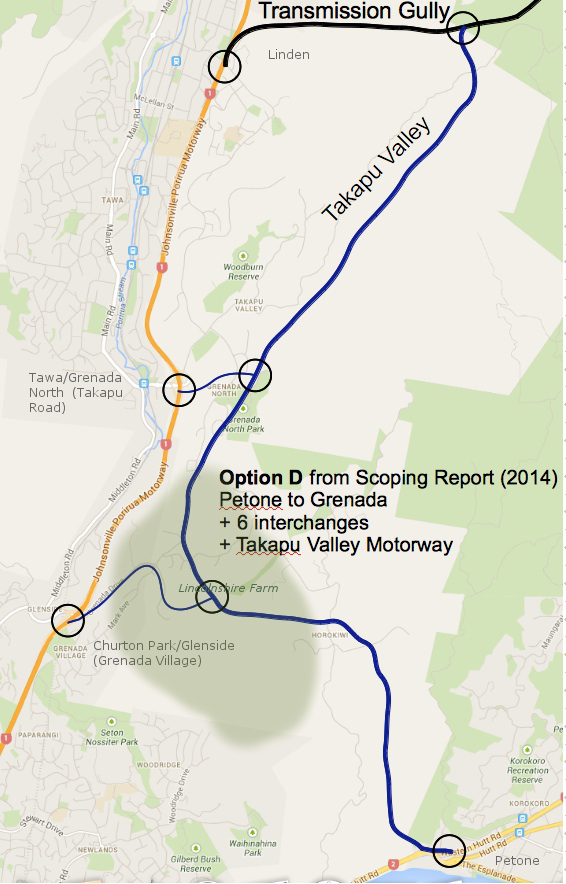
Option D: Petone to Transmission Gully
Option D doesn’t bother connecting to SH1 at all, instead opting to re-package the old Transmission Gully route (scroll down) up Takapu Valley.
So if you are coming from Petone on the P2G, and you want to go to Tawa or Porirua, you have to get off the P2G and noodle through two or three roundabouts to do it. If you stay on the P2G, you are shunted directly onto Transmission Gully northbound (no option to go east to Linden).
Tawa still gets that exciting new interchange, but instead of running parallel to SH1 to the south, there’s a link road that curves up under a new Jamaica Drive flyover and connects to the P2G (which now runs behind Grenada North) at yet another interchange.
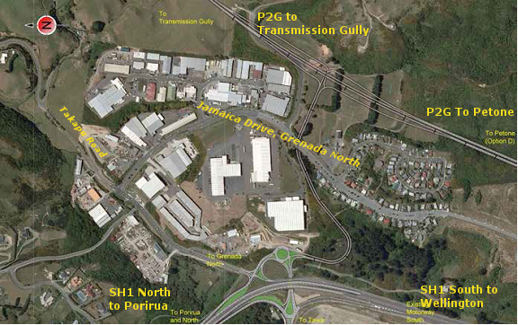
Figure 17-5: New Grade Separated Interchange at Tawa
Option D wipes out the Grenada North sports fields, and bisects all of the properties on the eastern side of Takapu Valley – including two that have been farmed by the same families since the 1800’s – taking out a few homes on the way through.
There are some diabolical gullies to cross at the bottom of Takapu Valley (read: EQ risk), and the proposed alignment runs between the Wellington gas main, the Wellington water main, and several sets of high voltage power pylons on the western side, and the active but unstudied Takapu spur of the Moonshine fault on the eastern side.
At the north end, where all of the sets of power lines converge on the Takapu Road sub-station, they need to tuck in an interchange with Transmission Gully while still theoretically allowing access to Belmont Regional Park as well as the substation itself. The terrain gets excitingly gorge-y up that end as well, and they’re going to need both flyovers and an underpass – more EQ risk.
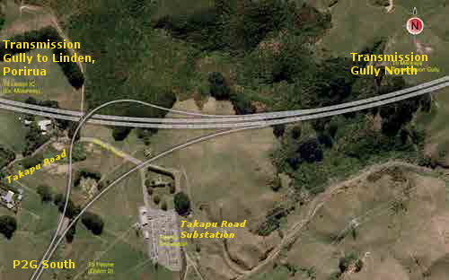
Figure 17-6: North Facing Ramps at Transmission Gully
Similar to Option C, instead of Middleton Road you could theoretically use the piece of the P2G between Tawa and Churton Park to bypass a crash on that short bit of SH1. You couldn’t use the bit through Takapu Valley, though, because the ramps at the north end are one-way – you can’t get onto the Takapu Valley stretch of P2G from Linden, and you can’t turn toward Linden from the Takapu Highway – in either case you can only continue along TG to Waitangirua and Whitby.
This is one of NZTA’s two preferred options.
NZTA says that Option D would take 7500 vehicles per day off of SH1, and that’s enough that if they did this option, they wouldn’t need to widen SH1.
The next post will discuss widening SH1, and the traffic figures that NZTA is using to justify this work. SPOILER: They don’t add up.
Links and notes:
The Petone to Grenada Project on the NZTA website.
The “Scoping Report” is NZTA’s Petone to Grenada Scoping Report 2014, available on the P2G’s Publications page.
The “PFR” is the Ngauranga Triangle Strategy Study Petone to Grenada Link Road Project Feasibility Report, 2010, by Sinclair Knight Merz (not online).
Map underlays for the four options are from Google maps. Alignments are approximate — refer to the Scoping Document for more precise alignments.
Flawed NZTA logic over Petone to Grenada Link Road options C & D?
Click graphic to enlarge
Is the Minister of Transport Gerry Brownlee being misled by NZTA?
This Ministerial reply seems to suggest so: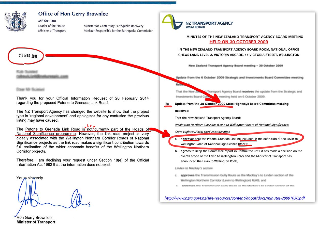
Petone to Grenada Link Road ‘Takapu Motorway tack on’ has big recreation implications for Belmont Regional Park
NZTA plans for a new motorway through Takapu Valley (option D), by tacking it onto the Petone to Grenada Link Road, has major implications for Wellington’s outdoor recreation users.
The proposed ‘Takapu Motorway – option D’ will effectively cut off the key access points to western Belmont Regional Park, leaving only southern and eastern points. These access points are important for mountain bikers, trampers, walkers and horse riders, with the carpark often overflowing on sunny weekends.
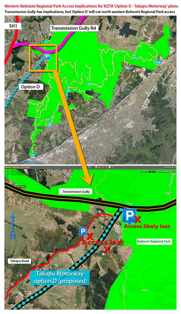
Belmont Regional Park access issues by proposed NZTA Takapu Motorway (option D)
We know the Greater Wellington Region is very proud of this park, so loosing these access points is of great concern. The whole plan has arrived suddenly, doesn’t exist in any district planning, is being driven with haste, will have little consultation, compared to Transmission Gully and the Petone to Grenada Roads which have had decades of consultation. This is madness.
We think the impacts on recreation in the Wellington Region also warrant a major rethink about this sudden adhoc last minute tack onto the Petone to Grenada Link Road.
Mayor angry SH58 ‘ignored’ again
Why is NZTA so obsessed with NOT upgrading SH58 ?
Mayor angry SH58 ‘ignored’ again
Fix up State Highway 58 before looking at “some dream new road” costing $250 million, Upper Hutt Mayor Wayne Guppy says.
The NZ Transport Agency (NZTA) says the Petone-Grenada Link Road – a proposed six-lane highway up the steep hill just south of Korokoro and eventually linking to Transmission Gully – offers major benefits to the Hutt Valley and wider region.
But Mr Guppy is unconvinced, and had said the proposed link would be the “death” of the Seaview/Gracefield commercial and industrial area as new development land in Grenada North is opened up for warehousing, trucking and hubbing operations. more on Stuff…
Endemic bullying culture in NZTA?
We’re fast developing an appreciation for how NZTA work. They’re running roughshod through communities and have unleashed a strategy to divide and conquer locals via Option C (widening existing SH1 motorway), or Option D (Takapu Motorway), and giving people 6 weeks consultation to fight major plans, that have no public planning, from a cold start. It’s unfair, unjust and unethical! Peter Dunne MP has alluded to this last night.
So it’s not surprising when we find letters like this NZTA letter bullying the Wellington City Council into submission: http://savethebasin.files.wordpress.com/2012/12/nzta_wcc_letter_121219.pdf
Is it time for Kiwis to take a harder look at our biggest Government agency’s behaviour and take the Chief Executive to task?