Analysis

Takapu Valley: Last clean headwaters of Porirua Harbour. Protect it from NZTA

NZTA are proposing a big road through the last undeveloped headwaters of Porirua Stream, which is a major tributary of the Porirua Harbour system.

Last week Wellington City Councillors voted to endorse the new Te Awaura-O-Porirua Harbour and Catchment Strategy Action Plan to clean up the Porirua catchment. Surprisingly, Councillors weren’t even told by officials that Takapu Valley is an such an important asset to Porirua Stream and Harbour health in their report to bulldoze Takapu Valley in the following agenda item.  This report (item 3.3) made no mention of the terrible impacts possible if councillors vote for Option D of the Petone to Grenada Road proposal.

There are no trout in the Takapu Headwaters.  The stream teams with native fish (Banded kokopu, upland bullies, long finned eel etc) that replenish the catchment, and the 50+ springs in the headwaters feed pure water into a neglected stream.  NZTA’s plan would see huge amounts of sediement, hydrocarbon and rubber pollution washing into the catchment continually.  This can’t be allowed to happen.Click here for a link to the biggest map image to view.Takapu-Valley-Porirua-Stream-Headwaters_m

Fish-surveys-Takapueel-&-frances

P2G and WGTN Resilience, Part 2: EQ and Natural Hazard Resilience

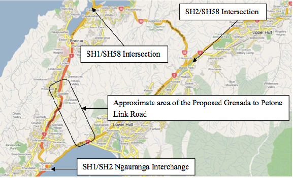
This is the second of three posts examining the effects of the proposed Petone to Grenada link road on the network and natural hazard resilience of the Wellington road network. This post covers Earthquake and Natural Hazard Resilience.

Part 1 looks at network resilience.

Part 3 takes a closer look at the challenges of the Hutt Valley in particular.

You can download the full report as a PDF [2MB] here: Resilience WGTN P2G_v1.4


Natural Hazard Resilience – Petone to Grenada

Jump to Takapu Valley Extension

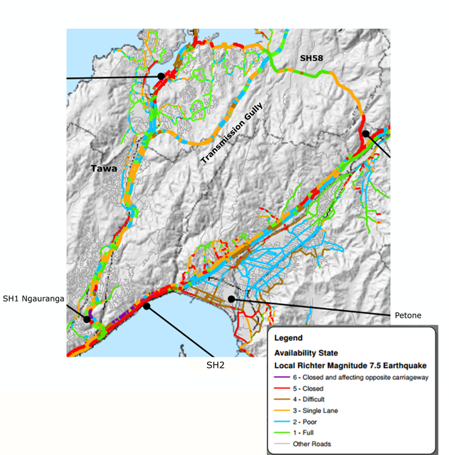
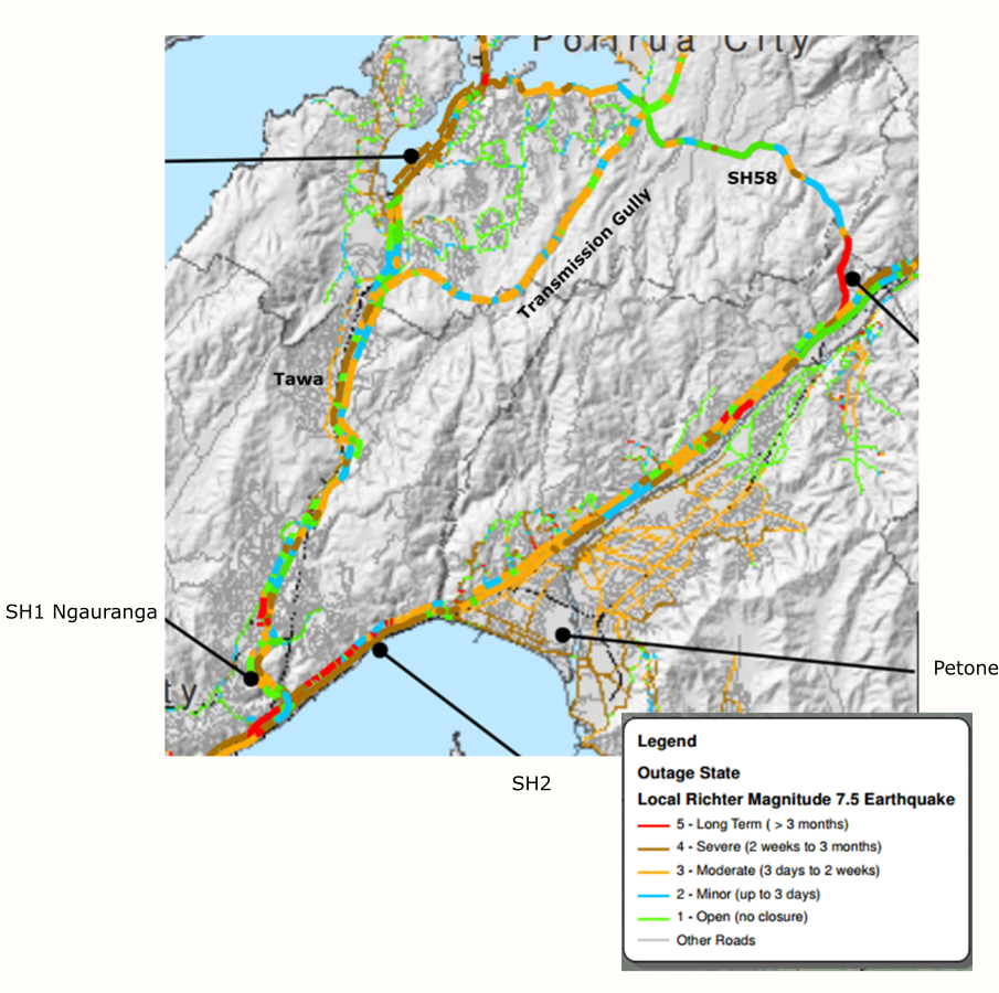
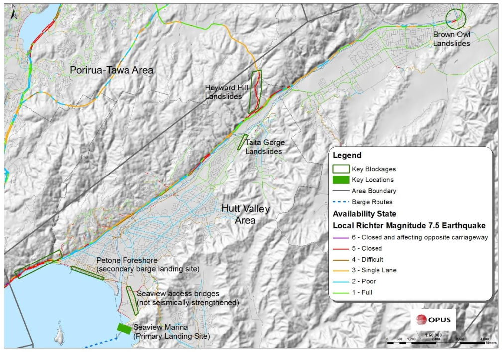
If there’s a big earthquake, both SH1 in the Gorge and SH2 along the harbour shore are expected to be closed. The map below shows “Availability State” – how bad will a given road be immediately after an event? For example, parts of SH1 through Tawa may be reduced to a single lane each way. Transmission Gully has a couple of short bits that may need a 4WD to get across.

Availability after 7.5 EQ

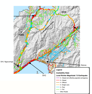
Availability map, from the Wellington Region Road Network Earthquake Resilience Study, Opus, 2012


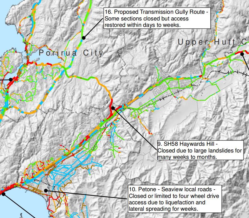
The map below shows “Outage State” – how long will a given stretch of road be in the state shown in the map above? They’ll be able to get most of SH1 usable, even through the Gorge – though maybe only via a few lanes – within a few days (though it appears they’ll need to divert to surface streets through Johnsonville). The northbound SH1 through Tawa will still be down to a single lane for two weeks to three months, though the southbound lanes should be back to normal much sooner. Transmission Gully likewise should be cleared in that 3 days to 2 weeks timeframe.

The Hutt, though, is expected to be cut off for weeks to months, depending on whether they can safely clear the slips along the shore there.


Outage after 7.5 EQ

Outage map, from the Wellington Region Road Network Earthquake Resilience Study, Opus, 2012


How will P2G perform in the event of a Magnitude 7.5 earthquake? What does it do for regional natural hazard resistance?

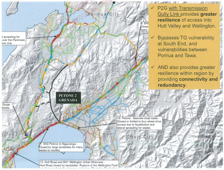
The slide NZTA presented to the local chief executives at their closed-door briefing back in November was this:

CE's P2G "Resilience" slide

P2G “Resilience” slide from “Petone to Grenada and SH58: Presentation to EAG August 2014”, released under OIA

We don’t get Availability or Outage information for P2G – instead, it’s represented as a black road, apparently constructed of a magical “unbreakium” that won’t fail in an earthquake.   Note that according to the sales pitch, Transmission Gully, which hasn’t even been built yet, is already a write-off and needs to be bypassed, as does the stretch of SH1 through Tawa, which as you can see from all that yellow and blue is likely to be the least damaged piece of highway in Wellington.

So how is P2G actually likely to fare in a major event?

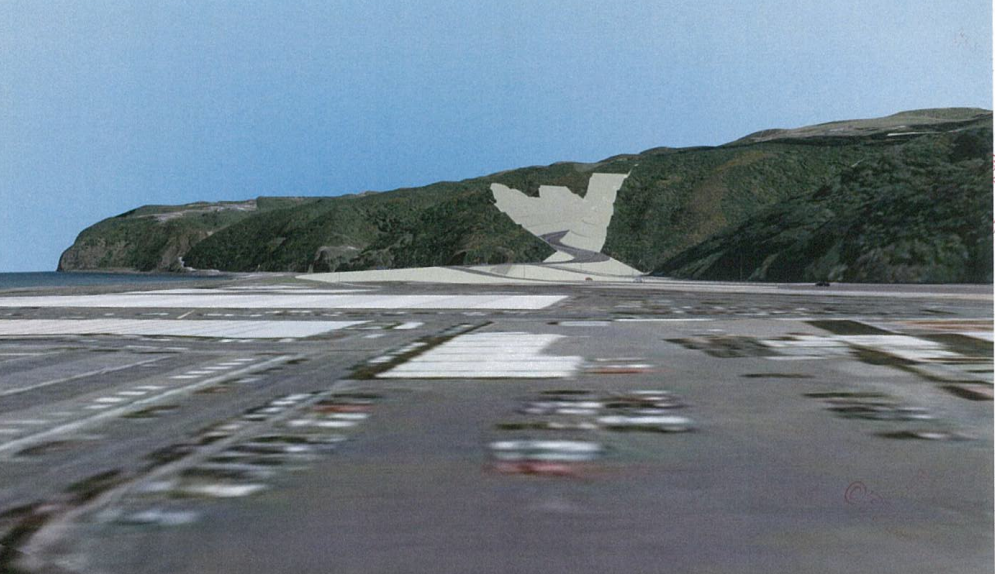
On the Petone/Korokoro side it has 60-85 meter deep double sided cuts:

proposed Korokoro canyon

from “Petone to Grenada and SH58: Presentation to EAG August 2014”, released under OIA


Cuts of that size – think canyon walls the height of the Intercontinental Hotel in Wellington, or the Quay Tower in Auckland – are capable of generating large landslips. The P2G Scoping Report 2014 notes in regard to the southern end of P2G that “failures in cut slopes can close the road for a few weeks”, and “high cut slopes reduce time for recovery.” Such slips can be very difficult to clear (think the Manawatu gorge), especially when working at the bottom of a canyon where aftershocks threaten to send more material down onto the diggers below. This means that the slips could not be quickly cleared, and the road might well be closed for at least weeks, and possibly even months.

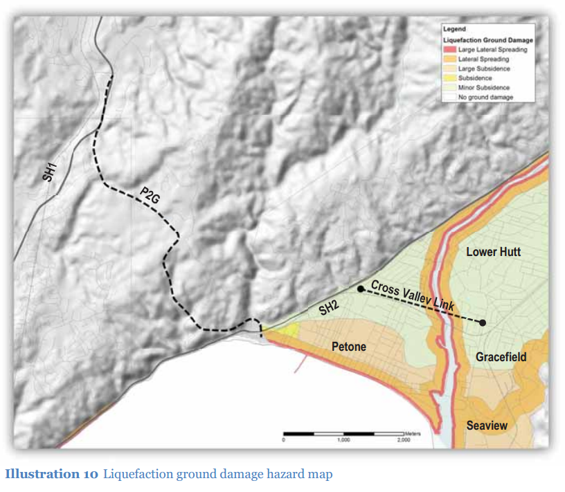
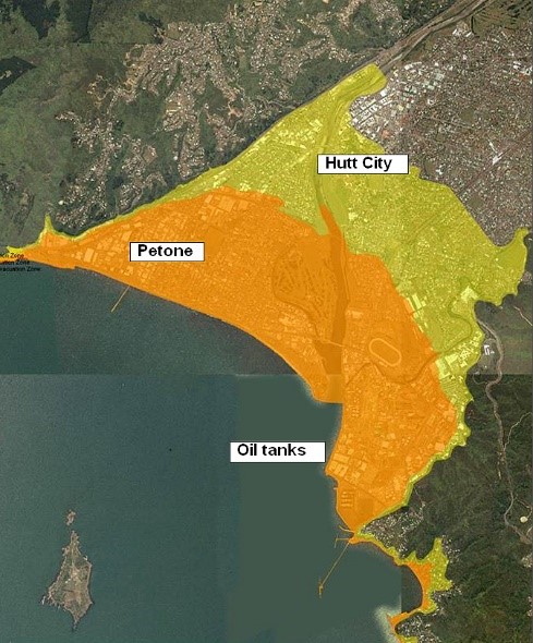
Then there is the fact that the road terminates in Petone, one of the most geologically/geotechnically problematic spots in the Wellington region, subject to subsidence, liquefaction and lateral spreading:

Petone Liquifaction map

Liquefaction and ground damage map from P2G Preliminary Geotech Appraisal, 2013

In addition, the area is subject to Seiches – a type of harbour tsunami that sloshes back in forth in a periodic oscillation, hammering Petone and the P2G terminus again and again.

Petone Tsunami zone

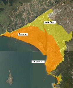
Petone Tsunami risk map from WREMO – the P2G terminus would be in the orange high-risk area at the far left


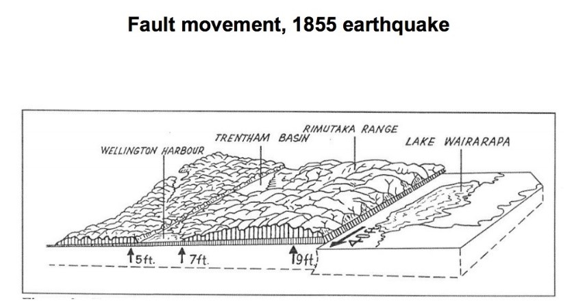
But it is potentially even worse than that. In the 1855 Wairarapa Earthquake Petone was uplifted about 2 meters.

1855 EQ ground movement

Ground movement, 1855 Wairarapa Quake

The Wellington and Wairarapa faults tend to induce movements in opposite directions, so if the next major regional EQ is along the Wellington fault, then all of Petone could be thrust back down ~2 meters over the course of 60 seconds. The end result would be that P2G, even if it was made of unbreakium (and note the P2G/SH2 interchange at Petone is mere meters from the Wellington Fault), could end up linking to little more than a rubble-strewn lake.

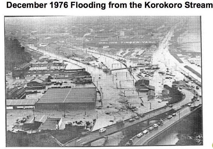
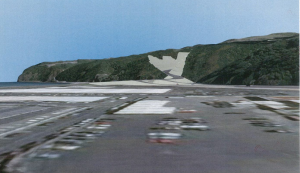
… And speaking of lakes, here’s the 1976 Korokoro Flood, caused by a large storm – that flooding is from Korokoro Stream, by the way, not the Hutt River. The photo below is of Ullrich Aluminium and the current Petone overbridge, right where P2G will connect to SH2 in Petone.

1976 Korokoro flood

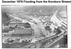
from GWRC presentation “Floods and People, a historic perspective of the Hutt River”

Petone is not the best place to put one end of a road intended to be a natural hazard resilience route, even if that road itself were not so vulnerable.


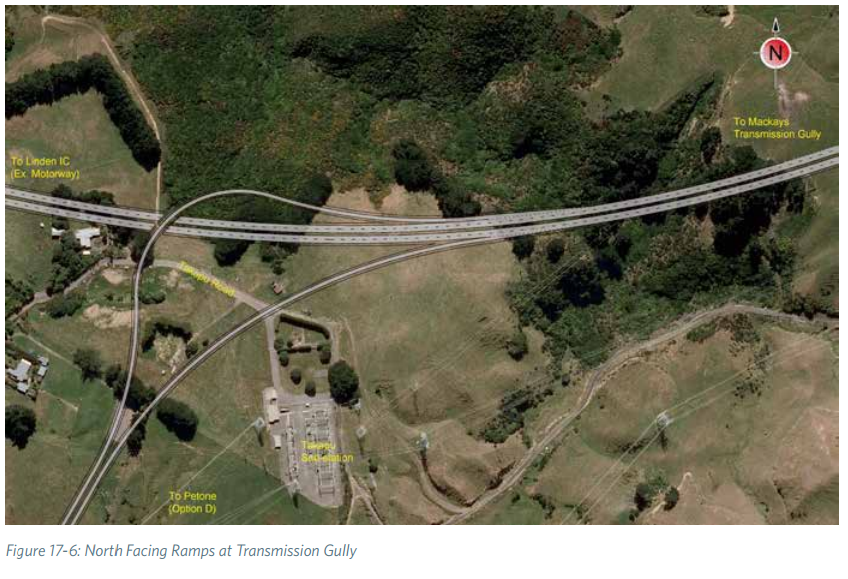
Natural Hazard Resilience – Takapu Valley


We’ve already addressed how the Takapu link does not offer very much in terms of network resilience, how about natural hazard resilience? The resilience specialist consulted for the P2G Scoping Report rated the Takapu Alignment highly.

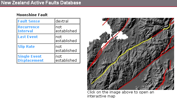
Unfortunately, the specialist made another mistake and also missed the fact that the proposed alignment runs directly along and atop an active uncharacterized fault:

Takapu/Moonshine Fault

from GNS Active Faults Database, accessed 29 March 2015


GNS has listed the Takapu Fault as a spur of the Moonshine Fault. The Moonshine Fault has a nice long failure interval – NZTA sources quote a figure of 11,000 years. Unfortunately, geotechnical sources we’ve consulted tell us that it’s not correct to assume that the Takapu spur operates at the same displacement or interval that the Moonshine Fault does. That’s why GNS has all those “not established”s in the database.

The fault itself is not necessarily the problem – you can’t throw a stone in Wellington without throwing it across a fault line, after all. The problem is that Takapu Valley is narrow and in places quite steep, and the best land has long been occupied by power pylons. Lots of them.

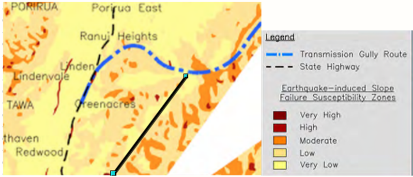
Even with the best alignment they could pick, the Takapu link road features “moderate height cuts that may fail, closing the route for up to two weeks”. (The section of SH1 it is supposed to “bypass”, by contrast, is expected to remain usable immediately after a quake.) The proposed narrow, two-lane Takapu extension runs through terrain with a moderate to high risk of slope failures, particularly at the southern end, which has an overall greater extent of at-risk slope than the Duck Creek and Linden sections of Transmission Gully.  (The worst bit is the southern end of the valley, unfortunately cut off in the image available.)

Takapu slope failure map

Images from Appendix A, Statement of evidence of Pathmanathan Brabhaharan (Brabha) (Geology and geotechnical engineering) for the NZ Transport Agency and Porirua City Council. 18 November 2011


This is the other shoe dropped by the fault line: even if you give the fault itself minimal clearance (and first they’d need to pay GNS to figure out where it actually is, because that bit you can see – where you can see it at all – is only where it happened to break the surface the last time it ruptured), the rock all through there has been fractured and crushed by the movement of the fault over millions of years.

When describing the resilience aspects of the southern end of P2G, the specialist repeats multiple times: “Away from poor rock conditions and faults [the cuttings] can be engineered to reduce failures in earthquakes”, “Likely to have better rock conditions being further away from the Wellington Fault Zone”, “Rock conditions are likely to be better being away from the Wellington Fault zone, and a short crossing of the inactive Korokoro Fault scarp.” If the fault isn’t the problem, the rotten rock near the fault is. It’s difficult to build on – as the Transmission Gully team has discovered attempting to site the foundations for the Cannons Creek viaduct, which nips off the top of the valley – and it’s far more likely to fail than even the usual Wellington “wheatbix” greywacke.

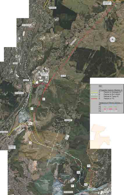
In a series of answers to questions raised by Hutt City Councillors, the P2G project team identified as key risks for Option D specifically:

  • Geotechnical, relating to the stability of the large cuts and differential settlement within road embankment fills required to form a link road in complex terrain
  • Geometric constraints, particularly with respect to horizontal curvature and gradient, as a result of difficult terrain

An alignment which gives a safe clearance to the fault line may not be possible, with the pylons to the west and the steep hill faces to the east – there’s also the Wellington water main and the gas main to avoid, particularly at the north end of the valley. They could be forced into an alignment requiring still higher, more vulnerable cuts into multiply-fractured, slip-prone hillslopes – though if they go too high, they’re into more power lines.

Speaking of which:

Pylons at Takapu Substation

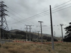
Photo taken at the north end of Takapu Valley, looking south along proposed road alignment.


The Wellington Region Road Network Earthquake Resilience Study released by Opus in August 2012 pays special attention to sections of the network – particularly in Upper Hutt – that are at risk from fallen power lines.

The alignment of the proposed Takapu extension weaves under and through the 33, 66, 110 kV lines and under the 220 kV lines and the HVDC link – right up through the spot where more than a dozen sets converge on the Takapu Substation. Even when well-sited, the pylons themselves may fail in an earthquake or severe weather event. One of the sets of pylons running alongside the proposed road alignment was built in 1924.


Conclusion


P2G does not provide very good regional natural hazard resilience, due to the vulnerabilities of the deep cuts on the Petone end, and the simple fact that it connects to Petone, one of the most geotechnically problematic areas in the region.

The Takapu Valley has mediocre to poor natural hazard resilience, due to its constrained alignment along an active fault line in steep, fault-fractured terrain. What it does do is add extra lane-kilometres of road that will need to be cleared (or abandoned) after a disaster – likely to be low priority compared to the adjacent Wellington RoNS corridor.

Part 3 looks at road access to the Hutt Valley after a major event.

Part 1 looked at network resilience, in the case of a crash or congestion.

You can download the full report as a PDF [2MB] here: Resilience WGTN P2G_v1.4


P2G and WGTN Resilience, Part 3: The Hutt Valley

This is the third of three posts examining the effects of the proposed Petone to Grenada link road on the network and natural hazard resilience of the Wellington road network. This post looks at road access to the Hutt after a major event.

Part 1 looks at network resilience.

Part 2 examines earthquake and natural hazard resilience.

You can download the full report as a PDF [2MB] here: Resilience WGTN P2G_v1.4


So how do we rescue the Hutt if the Big One hits?


As described in the previous post, all of the routes in or out of the Hutt Valley are vulnerable to long outages following a major event. The Wellington Region Road Network Earthquake Resilience Study (Opus, 2014) modelled the effects of a 7.5 Magnitude earthquake, and determined that the Hutt Valley should expect to be isolated for “many weeks to months”. They’re cut off from Wellington by slips where SH2 runs along the harbour, cut off from the Wairarapa by slips closing SH2 over the Rimutakas, and cut off from Kapiti by most of the Akatarawa road having fallen down a gully (again).

Unlike other parts of Wellington, Porirua and Kapiti, the Hutt Valley is not well-served by water access. The current plans require relief by air to Trentham, or supply boats making beach landings at Petone or Seaview. Petone, as discussed previously, is vulnerable to a variety of quake-related problems: liquefaction, lateral spreading, tsunami, and – in the case of a failure on the Wellington Fault – significant downthrust which may drop that end of the valley by up to two metres.

Seaview has the same tsunami and seiche risk as Petone, and will require bailey bridges to reach, as the current bridges are not expected to be usable after a major event. Supplies and personnel landed at Petone or Seaview then have the entire length of the valley to traverse.

Petone-Seaview planning map

from Restoring Wellington’s Transport Links after a Major Earthquake, Wellington Lifelines Group and WREMO, March 2013


The best candidate for a resilience road for the Hutt is SH58, which in conjunction with Transmission Gully actually looks pretty fantastic:


Haywards outage map

Wellington Region EQ Resilience Study, Opus, 2012


…except for that pesky red bit right at the end, where the road sidles along a hillside and then swings down to join SH2. This is a far shorter section of road than either SH2 over the Rimutakas or SH2 along the harbour shore, and unlike the proposed Petone to Grenada link, the road is not at the bottom of a 20 storey canyon.

Towards the Porirua end, SH58 connects directly to Transmission Gully, which, supposedly built to the highest seismic standards, is being touted as the EQ saviour of the (rest of the) region. At the eastern end, SH58 connects at the boundary between Upper and Lower Hutt, providing good access to both ends of the valley. It’s a short, straight shot on good roads to Trentham, where the Army Camp and racecourse form a natural logistics centre.   SH58 would be the lifeline for the 150,000 people of the Hutt.

At the 9th March meeting of the Regional Transport Committee, a vote was taken to (finally) upgrade the interchange between SH58 and SH2. With that work already approved, and funding freed up by the Transmission Gully PPP burning a hole in NZTA’s pocket, now is the ideal time to bring that dodgy last couple of km up to scratch and give Hutt Valley a real resilience solution.

Additional reading: Wellington Lifelines Group


Conclusion

Where Petone to Grenada proposes an improvement in an area of poor network resilience, SH58 must become a priority for regional disaster resilience.

Part 1 looked at network resilience.

Part 2 examined earthquake and natural hazard resilience.

You can download the full report as a PDF [2MB] here: Resilience WGTN P2G_v1.4


P2G and WGTN Resilience, Part 1: Network Resilience

This is the first of three posts examining the effects of the proposed Petone to Grenada link road on the network and natural hazard resilience of the Wellington road network. This post covers Network Resilience.

Part 2 looks at earthquake and natural hazard resilience.

Part 3 takes a closer look at the challenges of the Hutt Valley in particular.

You can download the full report as a PDF [2MB] here: Resilience WGTN P2G_v1.4


Background

If the stars and the BCR align – and NZTA has been working very hard on the latter, to be sure — Wellington will be getting a new road, the Petone to Grenada Link road. To recap a bit, here’s the situation. The extra blue lines are a rough indication of NZTA proposals for Petone to Grenada. The brownish one shows a rough outline of Transmission Gully.

Wellington road map

Wellington road map, with TG and P2G added, problem area circled.

As you can see in that red circle, there are currently two routes out of Wellington:

  1. SH1 goes up Ngauraga Gorge, through Johnsonville, Churton Park, Tawa and Porirua to (eventually) Kapiti.
  2. SH2 runs along the edge of the harbour and goes through Petone, Lower and Upper Hutt, and then over the Rimutaka Hill Road to the Wairarapa.

By “cutting the corner” to connect these two routes, P2G is intended to increase resilience for the Wellington Region.

However, there are two different meanings of “resilience”, and each has to be looked at separately.

  • Network Resilience – The ability to route around congestion, crashes, and other events that temporarily block a part of the road.
  • Natural Hazard Resilience – The ability of any given road to withstand damage from storms, earthquakes, etc., and how quickly a damaged road can be brought back into service.


Network Resilience – Petone to Grenada

Jump to Takapu Valley Extension

Improving network resilience is especially important for areas where there are no alternatives – and this is the big problem with the Ngauranga Triangle region, in the red circle above.

Neither SH1 through the Gorge nor SH2 along the harbour shore have much in the way of alternatives, if there’s a blockage. For instance, if a crash blocks SH2, the only way to get into Lower Hutt is to go up SH1 all the way to SH58 up at the top of the map there, and then come back south.

With P2G, if you need to get to the Hutt and SH2 is blocked, you’ll be able to take SH1 up the Gorge and cut across P2G to get to Petone, instead of going all the way up to TG and SH58. But see what they’ve done:

Option C Map

Option C, Tawa end, from NZTA Petone to Grenada Project website

The main connection to P2G is all the way up at Tawa. There’s access from Churton Park via Mark Avenue, a 5km shorter trip, but only via surface streets and roundabouts (the unmodified Churton Park interchange is just out of the image at the left). If Hutt-bound traffic tries to use P2G to route around a blockage on SH2, the undersized linkage will quickly clog northbound SH1 at the Churton Park interchange.

The same applies if there is a problem in the AM peak – Hutt drivers will try to take the shortest route, and be balked by the Mark Avenue roundabout.

There is less of a problem if the blockage is on SH1 in the Gorge, depending on how far north people are going/coming from, and whether they get the word early enough to get onto P2G at Tawa or get stuck queuing at Churton Park – but SH1 drivers can and do avoid the Gorge via designated roads through Broadmeadows and Khandallah. Hutt drivers have nowhere else to go.

To sum up: the best option for network resilience would be to make the primary P2G connection via a robust, preferably high-speed interchange at Churton Park. This is basically what the 2009 Feasibility Study recommended. The 2014 Scoping Report also identified a connection at or near Churton Park as “provid[ing] the best network-wide performance results” – unfortunately, an analysis error resulted in this option being dropped from consideration before it could be developed further.


Network Resilience – Takapu Valley


Not content to stop at Churton Park, or even at Tawa, NZTA has proposed extending Petone to Grenada up Takapu Valley along the rejected Transmission Gully route, to connect with the main TG alignment just east of Linden.


Link Road Options Map

Link Road Options Map, from NZTA Petone to Grenada Project website


This Takapu extension, they say, “provides a complete bypass” for a short (~3km) section of SH1 though Tawa, and an equally short (~2-3km) section of Transmission Gully at Linden. Unfortunately, the resilience specialist who gave the Takapu option such a high rating in the Scoping Report missed the fact that the connection to TG at the top of the valley is via one-way ramps:


One-Way Ramps at Takapu/TG

Takapu-Transmission Gully interchange at Cannons Creek viaduct, from the Scoping Report


If you tried to use the Takapu link as a bypass for a crash in Tawa, you’d be stuck on TG all the way to the northeast corner of Whitby, many km out of your way, and have to make your way back via surface streets.

Even if they changed the one-way ramps to a full interchange, there are already alternate routes between Tawa and Linden – Main Road on the west side of SH1 and Woodman Drive on the east side – do we really need to spend $60-140M on another one?

Conclusion


The Petone to Grenada road has the potential to provide significant improvements to regional network resiliency, especially if the interchange at Churton Park is improved so it can efficiently handle high speed, high load traffic flow between SH1 and P2G.

Due to the one-way ramps and the limited geographic separation from SH1, TG, and nearby junctions, and the existence already of multiple alternate routes, the proposed Takapu extension to Transmission Gully does not contribute significantly to network resiliency.

Part 2 examines earthquake and natural hazard resilience.

Part 3 looks at road access to the Hutt Valley after a major event.

You can download the full report as a PDF [2MB] here: Resilience WGTN P2G_v1.4


Five Roundabouts

…is how many roundabouts Takapu Valley and Grenada North residents will need to traverse to get into Tawa, according to the latest design from NZTA.  It appears pedestrian and cycle commuters between the Takapu Road train station and Grenada North will be expected to navigate at least four of those.  Because it’s all about reducing congestion and improving safety.  (Yes, that was sarcasm.)

NZTA's proposed Tawa interchange

NZTA’s proposed Tawa interchange

Transmission Gully Road changes traffic flows north from Wellington – SH1 vs SH2 (& SH58)

We were wondering what Transmission Gully Road would do to Wellington traffic flows once completed?  Transmission Gully will shift the main Wellington northern corridor east, bissecting SH58 at Judgeford.  What would this mean if you were a truck heading north from Wellington? Save for a few traffic lights on SH2, your route is clearly much better via SH2 and SH58 for fuel economy and wear and tear (see blue line below).  So why are NZTA saying they need to invest $50-150m on extra capacity between Tawa and Porirua (SH1 widening or bulldozing rural Takapu Valley to make a ridiculous short parallel motorway), when for much less money they could remove traffic lights and fix a few bad corners on SH58?

Transmission Gully changes to traffic flows SH1 vs SH2 north from Wellington

Transmission Gully changes to traffic flows SH1 vs SH2 north from Wellington

These sudden proposals (options C and D) have arrived without Council knowledge and have totally circumvented the regional and district planning process.  It’s clear to see that they’re being rushed through with haste by NZTA with no regard to wider regional needs.  We say build Transmission Gully, and build Petone to Grenada Road if necessary, but wait to see what will happen before destroying communities and a whole rural valley.

NZTA tell us traffic volumes are going to miraculously skyrocket after Transmission Gully sending much more traffic past Tawa.  We find this incredibly hard to imagine given traffic volumes have been dropping in Wellington, and when this elevation infographic diagram above suggests that Hutt Traffic (and possibly much Wellington Traffic) will prefer SH2/SH58 (over SH1 past Tawa) to Levin and beyond, further reducing flows.

Overall, this adhoc major infrastructure building by NZTA in road project silos is not serving the Wellington Region well.  All these roads need to be put through a proper established strategic planning framework.

Intro to the Options

A quick rundown for viewers just joining us…

Okay, so what is the deal with this road?

Here’s the current road layout in Wellington. The “Project Area” we’re talking about here is the big wedge from basically where SH1 and SH2 split in the south, up to SH58 in the north.

PFR Project Area

Figure 4.1 from the SKM Project Feasibility Report

NZTA and various local bodies have been talking about some version of this link road since at least 1991, and there are two primary problems they want the road to solve.

Problem 1: CONNECTIVITY

You’ve got SH1 in the west, and SH2 going up the Hutt, and there’re currently only two ways to get between one and the other:

  1. go down the Gorge at Ngauranga, and back up SH2 along the coast
  2. noodle around the Porirua inlets on SH58 and go down Haywards Hill

“Resilience” has become the buzzword du jour, and this is essentially an aspect of connectivity. If that bit of SH2 along the harbour gets eaten by the sea, or the hill falls on it, it’d be nice to not have to go all the way up to SH58 at Pauatahanui to get back to Petone.

Problem 2: CONGESTION

Ngauranga Gorge – it’s a big steep hill, with a couple of sharpish bends. In the AM peak, traffic backs up from here to Tawa. Out-of-peak, though, traffic flows are fine.

SH2 Aotea along the harbour to Petone – everything slows to a crawl at the PM peak, backing up all the way into town.

Really, this is just “connectivity” again – if we had another way to get from A to B, there’d theoretically be fewer cars using the congested routes.

So what’s the (current) plan?

Options from the Scoping Doc

Figure 12.8: Options Selected for Development, from the Scoping Report


Clear as mud?

What the Petone to Grenada proposal does, basically, is builds a second gorge road, so in addition to SH1 coming up Ngauranga, there will be a new, slightly steeper gorge road coming up Korokoro from Petone and joining SH1 at… well there’s where it gets tricky.

They came up with four options for the Northern end.


Option A – Petone to Grenada

Option A map

Option A: Petone to Grenada

Option A goes through Lincolnshire Farm to the Mark Avenue roundabout, and then runs along the existing Grenada Drive to the existing Grenada Interchange (Churton Park/Glenside) with SH1. Grenada Drive, the SH1 interchange, and the Mark Avenue roundabout would all be upgraded. This is basically the way that everyone has been expecting the link road to connect since the first detailed study in 1991. It’s written into the Lincolnshire Farm Structure Plan, and the local property lines have been drawn to keep out of the way.

Option A has the fewest number of interchanges, and according to the Scoping Report, does the best job of making traffic flow smoother and faster. It also has the least number of slip-vulnerable road cuts, and does the least amount of damage to the landscape.

This is one of the two “rejected” options.

NZTA says that if they go with this option, they would also need to widen SH1 from the Grenada interchange north to Transmission Gully. More on that later.


Option B – Petone to Not-Quite-Tawa

Option B map

Option B: Petone to Not-Quite-Tawa

Option B connects to SH1 at a new interchange between the existing Tawa and Churton Park interchanges. The bit from the Mark Ave roundabout down Grenada drive is used as a link road (as-is, where-is apparently). The new interchange with SH1 south of Tawa is one-way pointing north. Meaning,

  • If you’re coming from south of Churton Park, you get onto the P2G from Churton Park via the Mark Avenue link road.
  • If you’re coming from north of Tawa, you get on at the new south-of-Tawa interchange.
  • If you’re coming from Tawa, Grenada North, or Takapu Valley, you’re stuffed, because they’ve also taken the southbound ramps off the existing Tawa interchange. To get to Wellington or Petone, you’ll need to take Middleton Road to Churton Park and best of luck from there.

Not surprisingly, this one has the worst traffic flows. Also, it’s more expensive, because they routed it through the old Northern Landfill.

This is one of the two rejected options.

NZTA says that they would also need to widen SH1 from the Tawa interchange north to Transmission Gully. More on that later.


Option C – Petone to Tawa

Option C map

Option C: Petone to Tawa

Option C is much like Option B, except that they manage to miss the Northern Landfill, and instead they go through a bunch of homes that have just started construction in Grenada North. They then swoop up to connect to SH1 at the existing Tawa/Grenada North interchange. There’s about 2km where the two motorways run parallel to each other, something like 50 meters apart.

Tawa gets this:

Proposed Tawa Interchange

Figure 16-4: Modified Interchange at Tawa

You’ve got traffic from two high-speed motorways joining each other through a series of roundabouts, and if you’re coming from Tawa, Grenada North, or Takapu Valley, you get to try and leap into the middle of that. Be sure to have your life insurance up to date. And if you’re one of those that currently walks or cycles between the train station and points east… well, don’t.

From a resilience perspective, this option has some moderate road cuts that could be vulnerable to slips. For more day-to-day issues, in theory you could use the bit from Tawa up through Lincolnshire and back down to Churton Park to get around a crash on SH1, if you didn’t want to use Middleton Road (or couldn’t get to Middleton road across the clogged roundabouts.)

This is one of the two “preferred” options.

NZTA says that Option C will also require widening SH1 from the P2G interchange north to Transmission Gully. More on that later.


Option D – Petone to Transmission Gully

Option D map

Option D: Petone to Transmission Gully

Option D doesn’t bother connecting to SH1 at all, instead opting to re-package the old Transmission Gully route (scroll down) up Takapu Valley.

So if you are coming from Petone on the P2G, and you want to go to Tawa or Porirua, you have to get off the P2G and noodle through two or three roundabouts to do it. If you stay on the P2G, you are shunted directly onto Transmission Gully northbound (no option to go east to Linden).

Tawa still gets that exciting new interchange, but instead of running parallel to SH1 to the south, there’s a link road that curves up under a new Jamaica Drive flyover and connects to the P2G (which now runs behind Grenada North) at yet another interchange.

Tawa Interchange Option D

Figure 17-5: New Grade Separated Interchange at Tawa

Option D wipes out the Grenada North sports fields, and bisects all of the properties on the eastern side of Takapu Valley – including two that have been farmed by the same families since the 1800’s – taking out a few homes on the way through.

There are some diabolical gullies to cross at the bottom of Takapu Valley (read: EQ risk), and the proposed alignment runs between the Wellington gas main, the Wellington water main, and several sets of high voltage power pylons on the western side, and the active but unstudied Takapu spur of the Moonshine fault on the eastern side.

At the north end, where all of the sets of power lines converge on the Takapu Road sub-station, they need to tuck in an interchange with Transmission Gully while still theoretically allowing access to Belmont Regional Park as well as the substation itself. The terrain gets excitingly gorge-y up that end as well, and they’re going to need both flyovers and an underpass – more EQ risk.

Transmission Gully Interchange

Figure 17-6: North Facing Ramps at Transmission Gully

Similar to Option C, instead of Middleton Road you could theoretically use the piece of the P2G between Tawa and Churton Park to bypass a crash on that short bit of SH1. You couldn’t use the bit through Takapu Valley, though, because the ramps at the north end are one-way – you can’t get onto the Takapu Valley stretch of P2G from Linden, and you can’t turn toward Linden from the Takapu Highway – in either case you can only continue along TG to Waitangirua and Whitby.

This is one of NZTA’s two preferred options.

NZTA says that Option D would take 7500 vehicles per day off of SH1, and that’s enough that if they did this option, they wouldn’t need to widen SH1.

The next post will discuss widening SH1, and the traffic figures that NZTA is using to justify this work. SPOILER: They don’t add up.


Links and notes:

The Petone to Grenada Project  on the NZTA website.

The “Scoping Report” is NZTA’s Petone to Grenada Scoping Report 2014, available on the P2G’s Publications page.

The “PFR” is the Ngauranga Triangle Strategy Study Petone to Grenada Link Road Project Feasibility Report, 2010, by Sinclair Knight Merz (not online).

Map underlays for the four options are from Google maps.  Alignments are approximate — refer to the Scoping Document for more precise alignments.

Petone to Grenada Link Road ‘Takapu Motorway tack on’ has big recreation implications for Belmont Regional Park

NZTA plans for a new motorway through Takapu Valley (option D), by tacking it onto the Petone to Grenada Link Road, has major implications for Wellington’s outdoor recreation users.

The proposed ‘Takapu Motorway – option D’ will effectively cut off the key access points to western Belmont Regional Park, leaving only southern and eastern points.  These access points are important for mountain bikers, trampers, walkers and horse riders, with the carpark often overflowing on sunny weekends.

Belmont Regional Park access issues by proposed NZTA Takapu Motorway (option D)

Belmont Regional Park access issues by proposed NZTA Takapu Motorway (option D)

We know the Greater Wellington Region is very proud of this park, so loosing these access points is of great concern.  The whole plan has arrived suddenly, doesn’t exist in any district planning, is being driven with haste, will have little consultation, compared to Transmission Gully and the Petone to Grenada Roads which have had decades of consultation.  This is madness.

“Ōhariu MP Peter Dunne is calling on NZTA to drop altogether proposals for a link road between the Transmission Gully Highway and the planned Petone to Grenada road “until it gets its act together.” 

We think the impacts on recreation in the Wellington Region also warrant a major rethink about this sudden adhoc last minute tack onto the Petone to Grenada Link Road.

Mayor angry SH58 ‘ignored’ again

Why is NZTA so obsessed with NOT upgrading SH58 ?

Mayor angry SH58 ‘ignored’ again

Fix up State Highway 58 before looking at “some dream new road” costing $250 million, Upper Hutt Mayor Wayne Guppy says.

The NZ Transport Agency (NZTA) says the Petone-Grenada Link Road – a proposed six-lane highway up the steep hill just south of Korokoro and eventually linking to Transmission Gully – offers major benefits to the Hutt Valley and wider region.

But Mr Guppy is unconvinced, and had said the proposed link would be the “death” of the Seaview/Gracefield commercial and industrial area as new development land in Grenada North is opened up for warehousing, trucking and hubbing operations.  more on Stuff…