
This is the first of three posts examining the effects of the proposed Petone to Grenada link road on the network and natural hazard resilience of the Wellington road network. This post covers Network Resilience.
Part 2 looks at earthquake and natural hazard resilience.
Part 3 takes a closer look at the challenges of the Hutt Valley in particular.
You can download the full report as a PDF [2MB] here: Resilience WGTN P2G_v1.4
Background
If the stars and the BCR align – and NZTA has been working very hard on the latter, to be sure — Wellington will be getting a new road, the Petone to Grenada Link road. To recap a bit, here’s the situation. The extra blue lines are a rough indication of NZTA proposals for Petone to Grenada. The brownish one shows a rough outline of Transmission Gully.
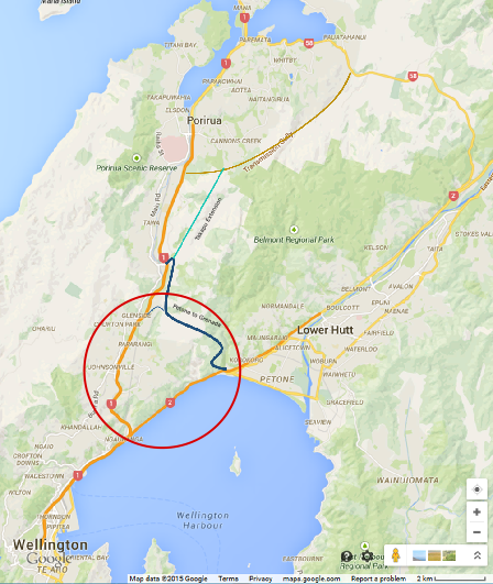
Wellington road map, with TG and P2G added, problem area circled.
As you can see in that red circle, there are currently two routes out of Wellington:
- SH1 goes up Ngauraga Gorge, through Johnsonville, Churton Park, Tawa and Porirua to (eventually) Kapiti.
- SH2 runs along the edge of the harbour and goes through Petone, Lower and Upper Hutt, and then over the Rimutaka Hill Road to the Wairarapa.
By “cutting the corner” to connect these two routes, P2G is intended to increase resilience for the Wellington Region.
However, there are two different meanings of “resilience”, and each has to be looked at separately.
- Network Resilience – The ability to route around congestion, crashes, and other events that temporarily block a part of the road.
- Natural Hazard Resilience – The ability of any given road to withstand damage from storms, earthquakes, etc., and how quickly a damaged road can be brought back into service.
Network Resilience – Petone to Grenada
Jump to Takapu Valley Extension
Improving network resilience is especially important for areas where there are no alternatives – and this is the big problem with the Ngauranga Triangle region, in the red circle above.
Neither SH1 through the Gorge nor SH2 along the harbour shore have much in the way of alternatives, if there’s a blockage. For instance, if a crash blocks SH2, the only way to get into Lower Hutt is to go up SH1 all the way to SH58 up at the top of the map there, and then come back south.
With P2G, if you need to get to the Hutt and SH2 is blocked, you’ll be able to take SH1 up the Gorge and cut across P2G to get to Petone, instead of going all the way up to TG and SH58. But see what they’ve done:

Option C, Tawa end, from NZTA Petone to Grenada Project website
The main connection to P2G is all the way up at Tawa. There’s access from Churton Park via Mark Avenue, a 5km shorter trip, but only via surface streets and roundabouts (the unmodified Churton Park interchange is just out of the image at the left). If Hutt-bound traffic tries to use P2G to route around a blockage on SH2, the undersized linkage will quickly clog northbound SH1 at the Churton Park interchange.
The same applies if there is a problem in the AM peak – Hutt drivers will try to take the shortest route, and be balked by the Mark Avenue roundabout.
There is less of a problem if the blockage is on SH1 in the Gorge, depending on how far north people are going/coming from, and whether they get the word early enough to get onto P2G at Tawa or get stuck queuing at Churton Park – but SH1 drivers can and do avoid the Gorge via designated roads through Broadmeadows and Khandallah. Hutt drivers have nowhere else to go.
To sum up: the best option for network resilience would be to make the primary P2G connection via a robust, preferably high-speed interchange at Churton Park. This is basically what the 2009 Feasibility Study recommended. The 2014 Scoping Report also identified a connection at or near Churton Park as “provid[ing] the best network-wide performance results” – unfortunately, an analysis error resulted in this option being dropped from consideration before it could be developed further.
Network Resilience – Takapu Valley
Not content to stop at Churton Park, or even at Tawa, NZTA has proposed extending Petone to Grenada up Takapu Valley along the rejected Transmission Gully route, to connect with the main TG alignment just east of Linden.

Link Road Options Map, from NZTA Petone to Grenada Project website
This Takapu extension, they say, “provides a complete bypass” for a short (~3km) section of SH1 though Tawa, and an equally short (~2-3km) section of Transmission Gully at Linden. Unfortunately, the resilience specialist who gave the Takapu option such a high rating in the Scoping Report missed the fact that the connection to TG at the top of the valley is via one-way ramps:
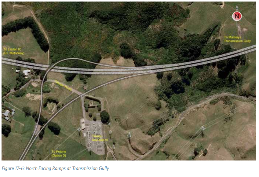
Takapu-Transmission Gully interchange at Cannons Creek viaduct, from the Scoping Report
If you tried to use the Takapu link as a bypass for a crash in Tawa, you’d be stuck on TG all the way to the northeast corner of Whitby, many km out of your way, and have to make your way back via surface streets.
Even if they changed the one-way ramps to a full interchange, there are already alternate routes between Tawa and Linden – Main Road on the west side of SH1 and Woodman Drive on the east side – do we really need to spend $60-140M on another one?
Conclusion
The Petone to Grenada road has the potential to provide significant improvements to regional network resiliency, especially if the interchange at Churton Park is improved so it can efficiently handle high speed, high load traffic flow between SH1 and P2G.
Due to the one-way ramps and the limited geographic separation from SH1, TG, and nearby junctions, and the existence already of multiple alternate routes, the proposed Takapu extension to Transmission Gully does not contribute significantly to network resiliency.
Part 2 examines earthquake and natural hazard resilience.
Part 3 looks at road access to the Hutt Valley after a major event.
You can download the full report as a PDF [2MB] here: Resilience WGTN P2G_v1.4