
This is the third of three posts examining the effects of the proposed Petone to Grenada link road on the network and natural hazard resilience of the Wellington road network. This post looks at road access to the Hutt after a major event.
Part 1 looks at network resilience.
Part 2 examines earthquake and natural hazard resilience.
You can download the full report as a PDF [2MB] here: Resilience WGTN P2G_v1.4
So how do we rescue the Hutt if the Big One hits?
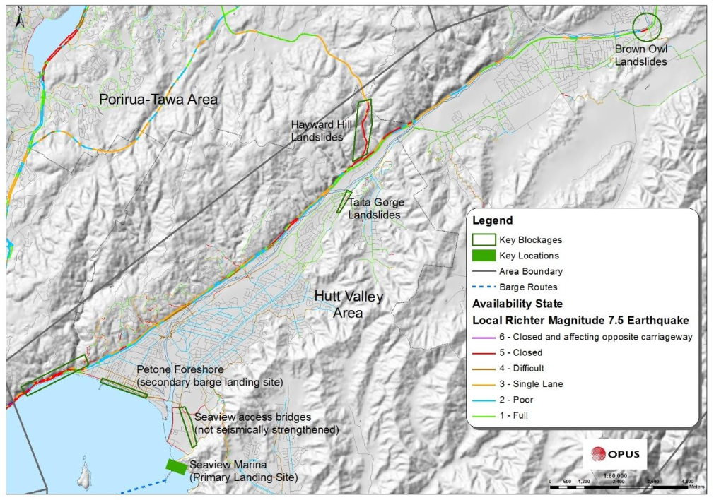
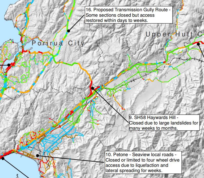
As described in the previous post, all of the routes in or out of the Hutt Valley are vulnerable to long outages following a major event. The Wellington Region Road Network Earthquake Resilience Study (Opus, 2014) modelled the effects of a 7.5 Magnitude earthquake, and determined that the Hutt Valley should expect to be isolated for “many weeks to months”. They’re cut off from Wellington by slips where SH2 runs along the harbour, cut off from the Wairarapa by slips closing SH2 over the Rimutakas, and cut off from Kapiti by most of the Akatarawa road having fallen down a gully (again).
Unlike other parts of Wellington, Porirua and Kapiti, the Hutt Valley is not well-served by water access. The current plans require relief by air to Trentham, or supply boats making beach landings at Petone or Seaview. Petone, as discussed previously, is vulnerable to a variety of quake-related problems: liquefaction, lateral spreading, tsunami, and – in the case of a failure on the Wellington Fault – significant downthrust which may drop that end of the valley by up to two metres.
Seaview has the same tsunami and seiche risk as Petone, and will require bailey bridges to reach, as the current bridges are not expected to be usable after a major event. Supplies and personnel landed at Petone or Seaview then have the entire length of the valley to traverse.
from Restoring Wellington’s Transport Links after a Major Earthquake, Wellington Lifelines Group and WREMO, March 2013
The best candidate for a resilience road for the Hutt is SH58, which in conjunction with Transmission Gully actually looks pretty fantastic:
Wellington Region EQ Resilience Study, Opus, 2012
…except for that pesky red bit right at the end, where the road sidles along a hillside and then swings down to join SH2. This is a far shorter section of road than either SH2 over the Rimutakas or SH2 along the harbour shore, and unlike the proposed Petone to Grenada link, the road is not at the bottom of a 20 storey canyon.
Towards the Porirua end, SH58 connects directly to Transmission Gully, which, supposedly built to the highest seismic standards, is being touted as the EQ saviour of the (rest of the) region. At the eastern end, SH58 connects at the boundary between Upper and Lower Hutt, providing good access to both ends of the valley. It’s a short, straight shot on good roads to Trentham, where the Army Camp and racecourse form a natural logistics centre. SH58 would be the lifeline for the 150,000 people of the Hutt.
At the 9th March meeting of the Regional Transport Committee, a vote was taken to (finally) upgrade the interchange between SH58 and SH2. With that work already approved, and funding freed up by the Transmission Gully PPP burning a hole in NZTA’s pocket, now is the ideal time to bring that dodgy last couple of km up to scratch and give Hutt Valley a real resilience solution.
Additional reading: Wellington Lifelines Group
Conclusion
Where Petone to Grenada proposes an improvement in an area of poor network resilience, SH58 must become a priority for regional disaster resilience.
Part 1 looked at network resilience.
Part 2 examined earthquake and natural hazard resilience.
You can download the full report as a PDF [2MB] here: Resilience WGTN P2G_v1.4