
A quick rundown for viewers just joining us…
Okay, so what is the deal with this road?
Here’s the current road layout in Wellington. The “Project Area” we’re talking about here is the big wedge from basically where SH1 and SH2 split in the south, up to SH58 in the north.
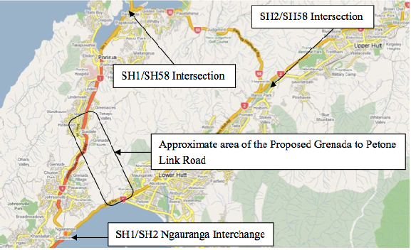
Figure 4.1 from the SKM Project Feasibility Report
NZTA and various local bodies have been talking about some version of this link road since at least 1991, and there are two primary problems they want the road to solve.
Problem 1: CONNECTIVITY
You’ve got SH1 in the west, and SH2 going up the Hutt, and there’re currently only two ways to get between one and the other:
- go down the Gorge at Ngauranga, and back up SH2 along the coast
- noodle around the Porirua inlets on SH58 and go down Haywards Hill
“Resilience” has become the buzzword du jour, and this is essentially an aspect of connectivity. If that bit of SH2 along the harbour gets eaten by the sea, or the hill falls on it, it’d be nice to not have to go all the way up to SH58 at Pauatahanui to get back to Petone.
Problem 2: CONGESTION
Ngauranga Gorge – it’s a big steep hill, with a couple of sharpish bends. In the AM peak, traffic backs up from here to Tawa. Out-of-peak, though, traffic flows are fine.
SH2 Aotea along the harbour to Petone – everything slows to a crawl at the PM peak, backing up all the way into town.
Really, this is just “connectivity” again – if we had another way to get from A to B, there’d theoretically be fewer cars using the congested routes.
So what’s the (current) plan?
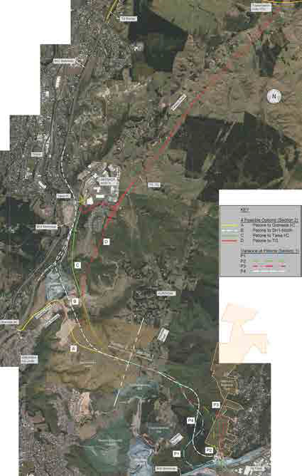
Figure 12.8: Options Selected for Development, from the Scoping Report
Clear as mud?
What the Petone to Grenada proposal does, basically, is builds a second gorge road, so in addition to SH1 coming up Ngauranga, there will be a new, slightly steeper gorge road coming up Korokoro from Petone and joining SH1 at… well there’s where it gets tricky.
They came up with four options for the Northern end.
Option A – Petone to Grenada
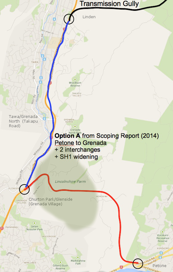
Option A: Petone to Grenada
Option A goes through Lincolnshire Farm to the Mark Avenue roundabout, and then runs along the existing Grenada Drive to the existing Grenada Interchange (Churton Park/Glenside) with SH1. Grenada Drive, the SH1 interchange, and the Mark Avenue roundabout would all be upgraded. This is basically the way that everyone has been expecting the link road to connect since the first detailed study in 1991. It’s written into the Lincolnshire Farm Structure Plan, and the local property lines have been drawn to keep out of the way.
Option A has the fewest number of interchanges, and according to the Scoping Report, does the best job of making traffic flow smoother and faster. It also has the least number of slip-vulnerable road cuts, and does the least amount of damage to the landscape.
This is one of the two “rejected” options.
NZTA says that if they go with this option, they would also need to widen SH1 from the Grenada interchange north to Transmission Gully. More on that later.
Option B – Petone to Not-Quite-Tawa
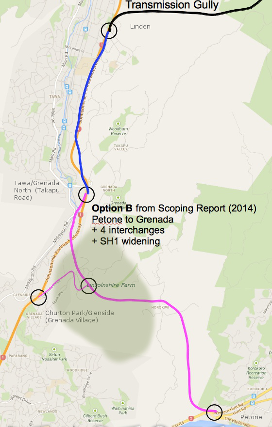
Option B: Petone to Not-Quite-Tawa
Option B connects to SH1 at a new interchange between the existing Tawa and Churton Park interchanges. The bit from the Mark Ave roundabout down Grenada drive is used as a link road (as-is, where-is apparently). The new interchange with SH1 south of Tawa is one-way pointing north. Meaning,
- If you’re coming from south of Churton Park, you get onto the P2G from Churton Park via the Mark Avenue link road.
- If you’re coming from north of Tawa, you get on at the new south-of-Tawa interchange.
- If you’re coming from Tawa, Grenada North, or Takapu Valley, you’re stuffed, because they’ve also taken the southbound ramps off the existing Tawa interchange. To get to Wellington or Petone, you’ll need to take Middleton Road to Churton Park and best of luck from there.
Not surprisingly, this one has the worst traffic flows. Also, it’s more expensive, because they routed it through the old Northern Landfill.
This is one of the two rejected options.
NZTA says that they would also need to widen SH1 from the Tawa interchange north to Transmission Gully. More on that later.
Option C – Petone to Tawa
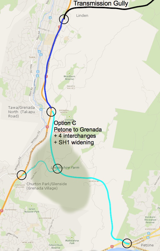
Option C: Petone to Tawa
Option C is much like Option B, except that they manage to miss the Northern Landfill, and instead they go through a bunch of homes that have just started construction in Grenada North. They then swoop up to connect to SH1 at the existing Tawa/Grenada North interchange. There’s about 2km where the two motorways run parallel to each other, something like 50 meters apart.
Tawa gets this:
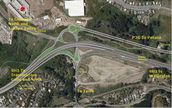
Figure 16-4: Modified Interchange at Tawa
You’ve got traffic from two high-speed motorways joining each other through a series of roundabouts, and if you’re coming from Tawa, Grenada North, or Takapu Valley, you get to try and leap into the middle of that. Be sure to have your life insurance up to date. And if you’re one of those that currently walks or cycles between the train station and points east… well, don’t.
From a resilience perspective, this option has some moderate road cuts that could be vulnerable to slips. For more day-to-day issues, in theory you could use the bit from Tawa up through Lincolnshire and back down to Churton Park to get around a crash on SH1, if you didn’t want to use Middleton Road (or couldn’t get to Middleton road across the clogged roundabouts.)
This is one of the two “preferred” options.
NZTA says that Option C will also require widening SH1 from the P2G interchange north to Transmission Gully. More on that later.
Option D – Petone to Transmission Gully
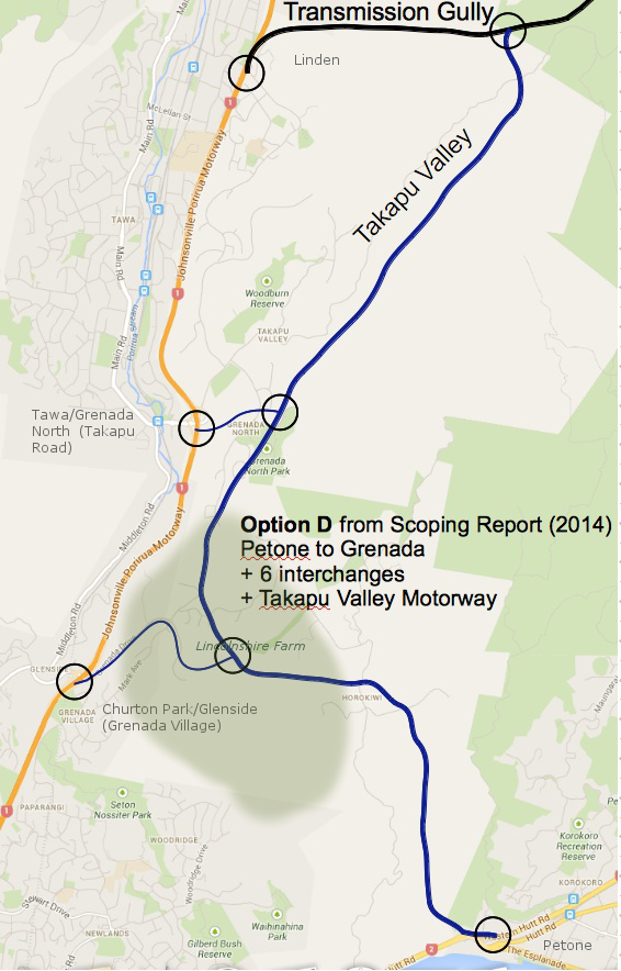
Option D: Petone to Transmission Gully
Option D doesn’t bother connecting to SH1 at all, instead opting to re-package the old Transmission Gully route (scroll down) up Takapu Valley.
So if you are coming from Petone on the P2G, and you want to go to Tawa or Porirua, you have to get off the P2G and noodle through two or three roundabouts to do it. If you stay on the P2G, you are shunted directly onto Transmission Gully northbound (no option to go east to Linden).
Tawa still gets that exciting new interchange, but instead of running parallel to SH1 to the south, there’s a link road that curves up under a new Jamaica Drive flyover and connects to the P2G (which now runs behind Grenada North) at yet another interchange.
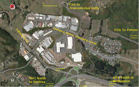
Figure 17-5: New Grade Separated Interchange at Tawa
Option D wipes out the Grenada North sports fields, and bisects all of the properties on the eastern side of Takapu Valley – including two that have been farmed by the same families since the 1800’s – taking out a few homes on the way through.
There are some diabolical gullies to cross at the bottom of Takapu Valley (read: EQ risk), and the proposed alignment runs between the Wellington gas main, the Wellington water main, and several sets of high voltage power pylons on the western side, and the active but unstudied Takapu spur of the Moonshine fault on the eastern side.
At the north end, where all of the sets of power lines converge on the Takapu Road sub-station, they need to tuck in an interchange with Transmission Gully while still theoretically allowing access to Belmont Regional Park as well as the substation itself. The terrain gets excitingly gorge-y up that end as well, and they’re going to need both flyovers and an underpass – more EQ risk.
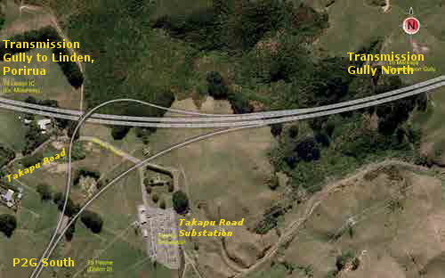
Figure 17-6: North Facing Ramps at Transmission Gully
Similar to Option C, instead of Middleton Road you could theoretically use the piece of the P2G between Tawa and Churton Park to bypass a crash on that short bit of SH1. You couldn’t use the bit through Takapu Valley, though, because the ramps at the north end are one-way – you can’t get onto the Takapu Valley stretch of P2G from Linden, and you can’t turn toward Linden from the Takapu Highway – in either case you can only continue along TG to Waitangirua and Whitby.
This is one of NZTA’s two preferred options.
NZTA says that Option D would take 7500 vehicles per day off of SH1, and that’s enough that if they did this option, they wouldn’t need to widen SH1.
The next post will discuss widening SH1, and the traffic figures that NZTA is using to justify this work. SPOILER: They don’t add up.
Links and notes:
The Petone to Grenada Project on the NZTA website.
The “Scoping Report” is NZTA’s Petone to Grenada Scoping Report 2014, available on the P2G’s Publications page.
The “PFR” is the Ngauranga Triangle Strategy Study Petone to Grenada Link Road Project Feasibility Report, 2010, by Sinclair Knight Merz (not online).
Map underlays for the four options are from Google maps. Alignments are approximate — refer to the Scoping Document for more precise alignments.